Students will be able to analyze and interpret data to describe patterns in the location of volcanoes and earthquakes related to tectonic plate boundaries, interactions, and hot spots. 8.E.5B.1
Content Knowledge Support
- Read and compete interactive science workbook pages 418-427.
Discussion Topics
- Using this interactive map of current earthquakes and volcanoes and this interactive map of earthquakes where would you say the worst place is in the world is to live in terms of experiencing a natural disaster such as an earthquake and/or volcano? Identify one specific location (start by picking the continent then work smaller towards a city). Explain why this area is so dangerous by researching how many people live there today and explain to these people why you believe another natural disaster is likely to occur in this area again in the future. Be sure to use the content from this week's module to support your explanation.
Recommended Exercises
|
(Level 4) Evaluation
|
(Level 5) Creation
|
Additional Exercises & Extensions
(Level 1) Comprehension
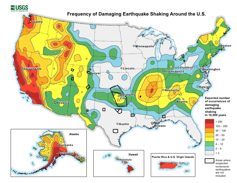
- Using this map explain why the west coast of the United States such as California has a greater risk of an extremely damaging earthquake occurring compared to the east coast of the United States such as South Carolina using 50-100 words. Be sure to use specific information from the content knowledge resources provided during this module to support your answer.
(Level 2) Application
- Carefully review and complete hotspots Google Form.
- Complete the what causes a volcanic eruption? EDPuzzle
(Level 3) Analysis
- Complete Mapping Plates SEPUP problem solving activity using this Lab TEMPLATE.
(Level 4) Evaluation
- Using this interactive map of earthquakes is there any chance of an earthquake occuring on the East Coast of the United States? (1 point) Explain using a Google Slide presentation why or why not using two or more specific evidence from this interactive (2 points) as well as two or more specific details from the content knowledge resources provided during this module (2 points).
(Level 5) Creation
- Create a short video using a screencasting application such as screencastify that demonstrates the location of most earthquakes in the United States using 2 or more images (2 points), text (1 point) and your voice (1 point). During the video include a segment explaining what people should realistically do if they live in these areas (1 point).
Additional Explorations
- At a hotspot, higher heat and lower pressure at the base of the lithosphere melts rock and forms magma. The magma rises through the cracks in the lithosphere and erupts to form volcanoes. Where will future islands be located? Estimate how long will this process take?
- Trace the Hawaiian Island chain and the Emperor Seamount chain and show the stationary nature of the hot spot versus the movement of the Pacific plate. How did the direction of this plate change over time?
Future Learning Connections (grades 9-12)
- Use mathematical land computational thinking to analyze seismic graphs to triangulate the location of an earthquake's epicenter and magnitude, and describe the correlation between frequency and magnitude of an earthquake.
- Analyze and interpret data to explain how natural hazards and other geologic events have shaped the course of human history.
- Obtain and evaluate available data on a current controversy regarding human activities which may affect the frequency, intensity, or consequences of natural hazards.
- Define problems caused by the impacts of locally significant natural hazards and design possible devices or solutions to reduce the impacts of such natural hazards on human activities.
English Language Learners

|
Module Review Resources

Click here to play Review Game Zone
Vocabulary Practice
Please provide any feedback you would like about this module below. This could include anything from typos, broken links, how the content was presented during the topics, your engagement in the content or your opinion about the assignment activities. Anything you wish to share that would help improve this module would be greatly appreciated.
